IEM Innovative Geospatial Technology: Pandemic Response & Mitigation
 The risks our nation and communities face today are complex and variable. Technological applications and innovative software, such as geospatial information systems (GIS), are powerful tools for emergency managers and decision makers to gain a greater understanding of where vulnerabilities exist and what actions to take to become more resilient.
At IEM, GIS technology is essential to our mission to build a safe, secure, and resilient world. We use GIS to provide rapid and expert analysis of complex data and conduct modeling and customized software solutions throughout all phases of emergency management. Our innovative Geospatial Services Team uses Esri software models and simulations to support our public health and pandemic response initiatives as well as to inform emergency managers of potential hazards and their consequences.
GIS & IEM Health
GIS technology’s ability to merge large quantities of data and express it visually in the form of interactive mapping applications/dashboards has been indispensable during the pandemic to allow scientists, public health professionals, and government officials to track the spread of the virus and predict case number trends. Our Geospatial team provides integral support to IEM Health’s vaccination efforts through the tracking and mapping of health data that is integrated into dashboards and shared with our clients, partners, and the public.
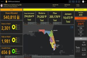
Innovative technology fueled IEM Health’s response to the pandemic since the beginning. IEM Health continues to generate COVID-19 modeling projections through artificial intelligence and dashboards to inform state and local leaders and their public health teams on case trends and identify response needs. As IEM Health’s COVID-19 testing and mass vaccination efforts expanded across the nation, GIS technology has been integral to track real-time data on the number of vaccinations and monoclonal antibody treatments given, doses of available vaccines, and locations of operational vaccination sites.
Our team currently manages and updates dashboards daily with data sent from over 200 vaccination sites across multiple states, including Virginia, Louisiana, Illinois, and Florida. The data we collect and use to generate the dashboards is vital to inform our partners and clients on the progress made in curbing positive case numbers and analyzing the trends in vaccinations and vaccine supplies. Mapping and tracking vaccinations visually also allows our team to establish vaccination sites in areas experiencing high numbers of positive COVID-19 cases and ensures our sites are accessible to vulnerable communities.
Innovative Mitigation & Analysis
To create resilient communities, emergency managers must anticipate and mitigate against potential threats. GIS technology is a valuable tool to analyze vulnerabilities across regions and within systems and can be used to generate risk assessments and assess strategies for recovery and response.
At IEM, we integrate GIS technology in our emergency management and disaster preparedness, response, recovery, and mitigation initiatives to create innovative and equitable outcomes for clients. Our interactive mapping applications layer multiple datasets to analyze vulnerabilities and inform planning and mitigation strategies to protect populations and critical infrastructure.
Our recent work includes developing interactive digital maps to support mitigation and infrastructure projects in Puerto Rico. We developed mapping applications to analyze the risk of sea level rise and severe hurricanes like Hurricane Maria to infrastructure as well as to strategically deliver federal mortgage emergency assistance to Puerto Rican homeowners affected economically by the pandemic.
IEM continues to leverage innovative technology to expand its capabilities to aid pandemic response efforts and mitigate against future disasters. Only through innovation can we build a safe, secure, and resilient world.

